I had just 35.8 miles left to finish my Long Trail end-to-end section hike. That’s out of 272 miles – the first 104 of which I’d hiked as part of my Appalachian Trail thru hike in 2013, and the rest of which I’ve done on weekends since. I was supposed to do the final section last fall but bad weather kept canceling the trip. For Memorial Day weekend, I wanted to do the hike regardless of weather so I could finally be an end-to-ender. I’ve also come to accept that black flies and mosquitoes will be horrendous at the end of May, but I’m so antsy to get on the trail, I don’t care. That is, I care very much, but I’d still rather be on the trail than not.
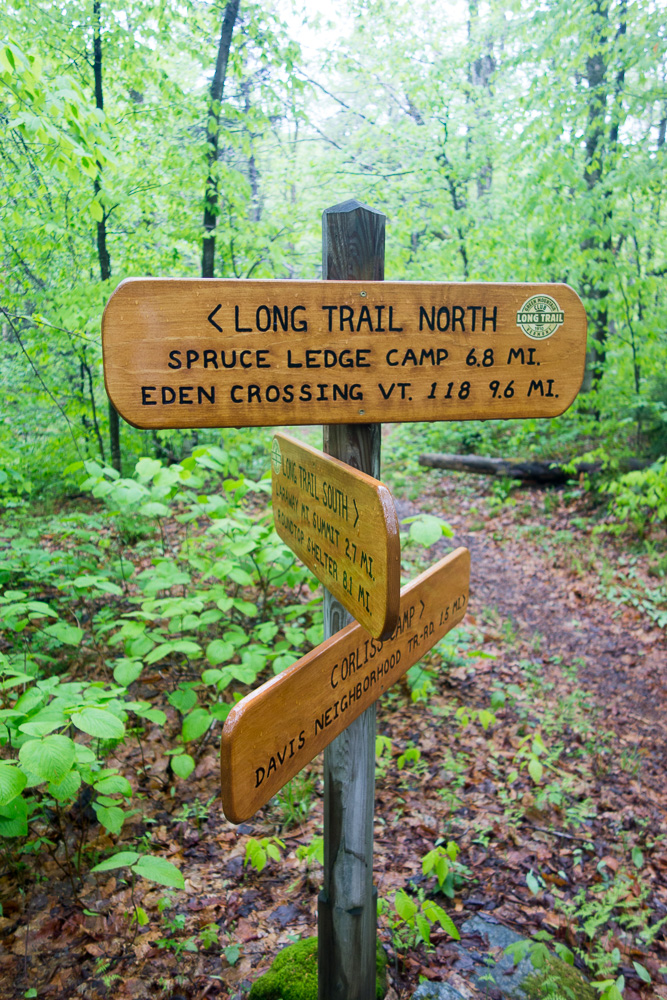
Switchfoot and Guthook got to my house Friday night so we’d be ready for an early start on Saturday. We were going to hike north from Smugglers’ Notch to Eden Crossing, but the forecast put rain and possible storms on Saturday, when we’d be going over the higher peaks of the trip, so we decided to flip and hike southbound at the last minute instead. The rain held off as we left two cars at Smugglers’ Notch, but it started in right as we got to the Eden Crossing trailhead. Luckily, we were in a very wooded area as we hiked south, and not too much rain got through the canopy. We made good time to Ritterbush Lookout (which was cloudy), took our time through the boulder-filled Devil’s Gulch, and got to Spruce Ledge Camp in time for an early lunch at its covered picnic table.


Photo by Guthook


The rain continued off and on as we hiked out after lunch over a few lesser peaks of Bowen Mountain at 2251′ and over Butternut Mountain at 2715′. There was fairly low visibility for the most part, but at least it wasn’t hot out. At one point, we were stopped to filter some water out of a stream when two owls started hooting at us. We could see them swooping around off in the distance, and they were huge! I was able to zoom in with my camera and get a blurry photo of one sitting in a tree staring at us.

Can you spot the owl in this photo?


We got to Corliss Camp early, around 4:00, after 9.6 miles for the day. This was supposed to be our short last day on the trail but when we changed it to our first day, there really wasn’t any other shelter whose mileage would have made sense. It stopped raining shortly before we arrived at the shelter so my clothes had mostly dried out when we got there. We hung out at the picnic table for a while, passing the time until an appropriate hour to cook dinner. Switchfoot started a small campfire with the wood that previous hikers had collected. Then we moved into the shelter to hang out. Guthook and I set up camp in there but Switchfoot still put up his tent, along with two other hikers who’d come in. Sometimes you run out of things to do when getting to camp too early but we still made it to about 9:00 before turning in.


It was brighter in the morning, and warmer too. After breakfast, we got started hiking up Laraway Mountain. I had to put my head net on fairly soon as the black flies were out in force. The trail was really pretty and a lot of the forest seemed to be carpeted in red trilliums. Going over the summit at 2790′, I had to be careful where I stepped to avoid all the moose poop. I really wish I could have seen a moose, but all I saw was evidence of the trail being its favorite bathroom. It was pretty muddy up there as well, to be expected since mud season is just over.


I was excited to get a view at Laraway Lookout since it had been socked in the last time I’d been there. We enjoyed the breeze there for a bit and then continued hiking downhill, past the tall rock walls that produce large ice columns in winter. They were all dripping water constantly so I can see where the ice comes from.


It was a nice walk downhill, where we crossed Codding Hollow Road. I tried to take a short snack break but the bugs were too bad and I kept moving, uphill again. We decided to get to Roundtop Shelter before breaking for a late lunch.


We hung out to eat behind the shelter, where there is a small view. Then we continued a short distance to another long break at Prospect Rock with its view of the Lamoille River. We ran into a few other hikers there, our first of the day, although we ran into a bunch more as we descended to the river and crossed the suspension bridge over one branch and rock hopped over the other. It wasn’t until shortly after we crossed Route 15 that we stopped seeing other hikers.


Photo by Switchfoot


The trail hopped onto the Lamoille Valley Rail Trail for a little bit, which I just rode on my bike a few weeks ago. From there, we turned up West Settlement Road, a dirt then logging road that took us almost all the way to Bear Hollow Shelter, just a little bit of trail at the end. 13.4 miles for the day.
The shelter is a three-sided one but the bugs didn’t seem too bad, and were curiously not coming into the shelter, so I still set up inside for the night. Switchfoot and Guthook found tent spaces, although the terrain wasn’t great for it. We enjoyed dinner and made it almost until dark before going to bed. The moon was so bright for the first half of the night that it still seemed like daylight when I woke up around midnight.


The morning started with a steep climb up to Whiteface Mountain at 3714′. It was so steep and rocky and wet, not to mention humid, that I was really looking forward to sitting at the view my map indicated was at the top. It turns out the view is mostly overgrown – you can only see it when standing on a very narrow rock. There really wasn’t anywhere comfortable to sit down and lounge so I decided to keep descending to Whiteface Shelter for my snack break, over more super steep, wet rocks.


We enjoyed the view from Whiteface Shelter while snacking, looking at Morse Mountain and Madonna Peak, the next mountains we’d be going over. It was really heating up now as we approached lunchtime. Of course, we had to go steeply down first before we could climb the next two mountains. There was a cool view of a beaver meadow as we went over Morse Mountain at 3486′ and down to Chilcoot Pass. Then we started the climb up to Madonna Peak at 3668′, ending on some ski trails to the summit. We had lunch in the sun at the top.


It was pretty hot in the sun so I laid on the summit building’s deck with my feet up on the picnic table until I realized I was in the way of two other hikers who suddenly appeared. We got moving again, down the ski trail a bit until we ducked back into the woods on the way to Sterling Pond. There were a ton of people there, most of them ignoring the signs asking hikers not to hang out on the shoreline, keep their dogs on leashes, etc. I can’t imagine being a backcountry caretaker here. It’s a really popular spot and people just show blatant disregard for the environment.


Guthook wanted to take a side trail around the pond so he met up with us shortly below it. Then Switchfoot and I took a short side spur to Elephant’s Head Cliff for the view. It was a very steep downhill to a decent view, although there wasn’t much room to hang out. We headed back up to the Long Trail, traversed up and around the slope a bit, and then started our long downhill to Barnes Camp at Smugglers’ Notch. It was so humid at this point, I kept trying to think of anyone I knew who owned a pool. But I’ve only even seen one pool in Vermont. It’s not really a state where you’d get much use out of a pool.


We finally made it down to the road, at 10.9 miles for the day and 272 miles for my not-quite-five-year section hike. Working for the Green Mountain Club, who created, maintains, and protects the Long Trail, I no longer feel like a fraud – I’ve now hiked all of it!


Leave a Reply